Current Dam Levels and Status of Water Sources
| Water Source |
Maximum Capacity
(ML) |
Current Volume
(ML) |
% Full |
Weekly Change
(ML) |
Weekly Change
(%) |
| Leslie Dam |
106,250 |
71,772 |
67.50% |
-223 |
-0.30 |
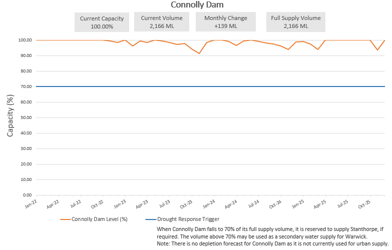
| Connolly Dam |
2,166 |
1,682 |
77.60% |
-16 |
-0.80 |
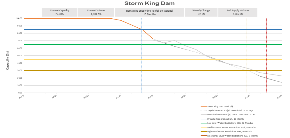
| Storm King Dam |
2,065 |
1,504 |
72.80% |
-37 |
-1.80 |
Last updated: 20 April 2026
Leslie Dam
Leslie Dam is approximately 12 km west of Warwick and is located on Sandy Creek. Leslie Dam has a catchment area of 603 km2 and is
owned and managed by Sunwater. Council holds a high priority water allocation from Leslie Dam to supply drinking water for Warwick, Allora, and Yangan.
Leslie Dam is the main water storage for the Upper Condamine Scheme, which supplies irrigation and urban water supply to users in Warwick and Cecil Plains. The scheme supplies Warwick's town water as well as that of Cecil Plains, but it also underpins irrigation in the region, serving about 100 bulk customers that use irrigation to grow crops. All water releases for irrigation are managed by Sunwater in accordance with the user agreements between Sunwater and license holders.
Releases for irrigation cease once the dam storage is less than or equal to 460.35 m AHD below full supply level, which is when the dam storage sits at 14,960 ML or 14.08% full. The remaining supply is reserved exclusively for town water supply for Southern Downs Regional Council.
Leslie Dam was surveyed in 2019 and was determined to have no material impact from silt levels.
Connolly Dam
Connolly Dam is situated approximately 15 km south of Warwick and is supplied by Rosenthal Creek. Connolly Dam has a catchment area of 134 km and is owned and managed by Council.
Connolly Dam is used at Council's discretion to supplement drinking water supplies. The latest river heights for Rosenthal Creek at Connolly Dam are recorded and reported by the Bureau of Meteorology. Data is provided for the previous 7 days and the water level is updated every 3 hours. Connolly Dam was surveyed in 2019.
It was determined that Connolly Dam had between 100-150 ML (estimated) less water due to siltation across the whole dam area. This had an immaterial impact on the water supply.
Storm King Dam
Storm King Dam is situated approximately 8 km south-east of Stanthorpe and is supplied by Quart Pot Creek. Storm King Dam is owned by the Council and has a catchment area of approximately 91 km2. Storm King Dam is the sole
supply for Stanthorpe's urban supply network.
The latest river heights for Quart Pot Creek at Storm King Dam are recorded and reported by the Bureau of Meteorology. Data is provided for the previous 7 days and the water level is updated every 3 hours.
Storm King Dam was surveyed in 2019. It was determined that Storm King Dam had between 100-150 ML (estimated) less water due to siltation across the whole dam area. This had an immaterial impact on the water supply. Desilting (Phase 1) of Storm King Dam is now complete and this work has restored some of the dam storage capacity.
Last edited date 20 Apr 2026