Current Southern Downs Water Restrictions and Dam Levels
.
Current restriction status by water supply
Water restrictions are applied by water supply area. This means one town or supply area may be on staged restrictions while another remains on the permanent daily water use target.
|
Water Supply Area
|
Main Water Source
|
Current Water Use Status
|
Daily Use Target
|
|
Stanthorpe
|
Storm King Dam
|
Drought Preparation
|
200L per person, per day
|
|
Warwick, Allora and Yangan
|
Leslie Dam / Connolly Dam
|
Drought Preparation
|
200L per person, per day
|
|
Killarney
|
Spring Creek Weir
|
Drought Preparation
|
200L per person, per day
|
|
Wallangarra and Jennings
|
The Soak / Beehive Dam
|
Drought Preparation
|
200L per person, per day
|
|
Dalveen
|
Bore supply
|
Drought Preparation
|
200L per person, per day
|
|
Leyburn
|
Bore supply
|
Drought Preparation
|
200L per person, per day
|
|
Pratten
|
Bore supply
|
Drought Preparation
|
200L per person, per day
|
.
Current dam and water source levels
|
Water Source
|
Maximum Capacity
(ML)
|
Current Volume
(ML)
|
% Full
|
Weekly Change
(ML)
|
Weekly Change
(%)
|
Status |
|
Leslie Dam
|
106,250
|
62,188
|
58.5%
|
-191
|
-0.2
|
Managed by Sunwater |
|
Connolly Dam
|
2,166
|
1,681
|
77.6%
|
-8
|
-0.4
|
Last 70% reserved for Stanthorpe only |
|
Storm King Dam
|
2,065
|
1,451
|
70.3%
|
-13
|
-0.6
|
Depletion dates: February 2027 with no restrictions and February 2028 with restrictions |
Last Updated: 29/06/2026
NOTICE – Stanthorpe Water Use Target Updates
Council has endorsed a change to the water use targets for three (3) Stanthorpe water levels during the current dry period to help extend available water supply for longer.
The revised Stanthorpe Drought Management Framework is as follows.
- Low Level Water Restrictions – changing from 170 Litres per person, per day to 150 Litres per person, per day
- Medium Level Water Restrictions – changing from 150 Litres per person, per day to 120 Litres per person, per day
- High Level Water Restrictions – changing from 120 Litres per person, per day to 100 Litres per person, per day
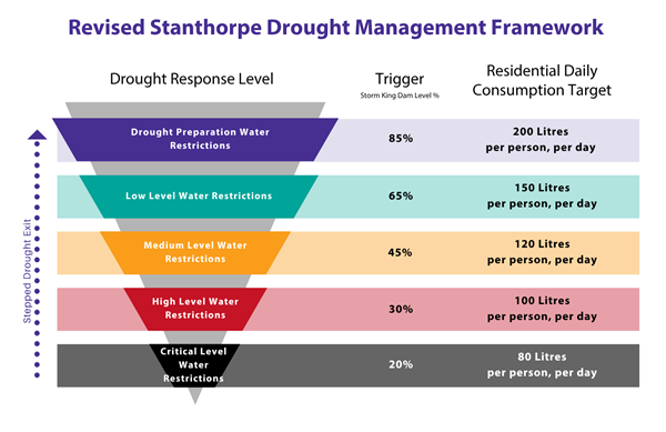
These updated targets apply to properties connected to the Stanthorpe reticulated town water supply and anyone using water from a Council standpipe or delivered by a mobile water tanker.
Restriction levels explained
Target:
- All of region: 200 litres per person, per day
Drought Preparation is the first stage of Council’s water supply response.
At this level, Council focuses on preparation, monitoring and community awareness.
This may include:
- monitoring dam, bore and storage levels
- reviewing water use across Council operations
- preparing community information and signage
- preparing water-saving fact sheets and resources
- monitoring standpipe use
- working with key stakeholders and government agencies
- encouraging long-term waterwise habits
Targets:
- Stanthorpe: 150 litres per person, per day
- Rest of region: 170 litres per person, per day
Low Level Water Restrictions are designed to reduce water use early while still allowing limited outdoor water use. Under Low Level Water Restrictions:
- Use of water permitted during the following times only: 6am – 8am and 5pm to 7pm
- Sprinklers are not permitted.
- Outdoor watering is limited to handheld hoses with trigger nozzles or buckets.
- Vehicle washing is permitted using a handheld hose with trigger nozzle, high-pressure cleaner, watering can or bucket filled directly from a tap.
- Cleaning paved or concrete surfaces is permitted using a handheld hose with trigger nozzle, high-pressure cleaner, watering can or bucket filled directly from a tap.
- Water play equipment connected to hoses is not permitted.
- Standpipe access limits apply – up to 5,000 litres per week, per property*.
* larger amounts can be approved by Manager Water& Wastewater based on families with more than 5 people living on a property.
Targets:
- Stanthorpe: 120 litres per person, per day
- Rest of region: 150 litres per person, per day
Medium Level Water Restrictions introduce stronger water-saving measures. Under Medium Level Water Restrictions:
- Watering hours remain, but outdoor watering is limited to alternate days.
- Pool or spa top-ups by unattended hose are permitted before 8:00am and after 6:00pm on alternate days, only if all available rainwater at the premises has been used first.
- Filling new or repaired pools requires written permission from the Manager Water and Wastewater.
- Filling or topping up children’s play pools is not permitted.
- Existing ponds supporting fish or bird life may be topped up to normal level using a watering can or bucket filled directly from a tap, up to 1,000 litres.
- Cleaning paved or concrete surfaces is only permitted where required to avoid or respond to an accident, fire, health hazard or other emergency. Must use a hand-held hose with trigger nozzle, high-pressure cleaner, watering can or bucket filled directly from a tap.
- Vehicle washing is permitted only using a watering can or bucket filled directly from a tap.
- Mobile water tanker filling is only permitted for use inside premises, specified building works, firefighting or stock watering, and requires written permission from Council.
- Anyone using water from a mobile water tanker or standpipe must comply with the current restrictions.
- Non-residential users are asked to aim for a 20% reduction in water use.
- Watering grass is not permitted.
- Standpipe access is permitted up to 4,000 litres per week per property*.
* larger amounts can be approved by Manager Water& Wastewater based on families with more than 5 people living on a property.
Targets:
- Stanthorpe: 100 litres per person, per day
- Rest of region: 120 litres per person, per day
High Level Water Restrictions involve a significant reduction in outdoor potable water use. Under High Level Water Restrictions:
- Gardens may be watered by watering can or bucket filled from a tap for a maximum of one hour per day, before 8:00am and after 6:00pm on alternate days.
- Topping up swimming pools or spas using potable town water is not permitted.
- Existing ponds supporting fish or bird life may be topped up to normal level using a watering can or bucket filled directly from a tap.
- Cleaning paved or concrete surfaces is only permitted where required to avoid or respond to an accident, fire, health hazard or other emergency. Must use a hand-held hose with trigger nozzle, high-pressure cleaner, watering can or bucket filled directly from a tap.
- Vehicle washing is permitted only using a watering can or bucket filled directly from a tap.
- Mobile water tanker filling is only permitted for use inside premises, specified building works or stock watering, with written permission from Council, and may be further restricted.
- Watering public gardens is not permitted unless approved in writing by the water service provider.
- Potable water use for green areas such as parks may be further restricted as determined by Council.
- Non-residential users are asked to aim for an additional 5% reduction in water use.
- Standpipe access is permitted up to 3,000 litres per week per property*.
* larger amounts can be approved by Manager Water& Wastewater based on families with more than 5 people living on a property.
Target:
- All of region: 100 litres per person, per day
Critical Level Water Restrictions are the highest restriction level.
This level focuses on essential water use for drinking, basic hygiene and core community needs.
At this level, Council may introduce further restrictions, limit non-essential water use, increase compliance activity and provide more frequent water security updates.
Specific rules will be confirmed and communicated if Critical Level Water Restrictions are introduced.
.
Drought Management Plan - Download and View
Council’s Drought Management Plan provides a staged framework for managing water supply during dry periods.
It includes:
- water supply schemes across the region
- restriction levels and water use targets
- trigger points
- demand management actions
- monitoring and reporting requirements
- contingency and emergency supply planning
- drought exit principles
Click here to download the SDRC Drought Management Plan
.
Waterwise Tools and Tips
Everyone can help reduce water use through simple daily actions.
Council’s Waterwise Community page includes practical tools and tips for households, gardens and businesses.
Click here to visit the Waterwise Community page
.
Fact Sheets, FAQs and Other Helpful Resources
Last edited date 29 Jun 2026